Embedded Files
This site is under construction 🚧🙂🚧 Message the mods at our Reddit community if you'd like to help. We'd be excited to have it!

Introduction
Introduction
Whether you plan to use solar panels, solar ovens, solar water heating, or any of the other variations of solar technology, it is best to do so with some understanding ahead of time including solar radiation, the best angles, and so on.
The tools, maps, and trackers on this page are intended to help make planning and installation easier. Some of these resources may help with estimating cost, panel angle
Tools & Maps
Tools & Maps
International
International
The Global Integrated Power Tracker (GIPT) (Interactive) is a multi-sector dataset of power stations and facilities worldwide. The tracker provides unit-level information on thermal power (coal, oil, gas, nuclear, geothermal, bioenergy) and renewables (solar, wind, hydro). The tracker includes data on unit capacity, status, ownership, fuel type, start year, retirement date, geolocation, and more. Each power facility is linked to a profile page, hosted on GEM.wiki, that provides further information.
Global Energy Monitor’s eight power sector trackers provide the source of underlying data: the Global Coal Plant Tracker, Global Oil and Gas Plant Tracker, Global Solar Power Tracker, Global Wind Power Tracker, Global Hydropower Tracker, Global Geothermal Power Tracker, Global Bioenergy Power Tracker, Global Nuclear Power Tracker."
Global Solar Atlas (Interactive) "Start exploring solar potential by clicking on the map. Select sites, draw rectangles or polygons by clicking the respective map controls. Calculate energy production for selected sites."
The Global Solar Power Tracker (Interactive) is a worldwide dataset of utility-scale solar photovoltaic (PV) and solar thermal facilities. It covers solar farm phases with capacities of 20 megawatts (MW) or more. The tracker also includes partial coverage of phases between 1 MW and 20 MW. For more information about inclusion criteria, please see our Methodology page. A solar project phase is generally defined as a group of one or more solar units that are installed under one permit, one power purchase agreement, and typically come online at the same time. The Global Solar Power Tracker catalogs every solar farm phase at these capacity thresholds of any status, including operating, announced, pre-construction, under construction, shelved, cancelled, mothballed, or retired. Each solar farm included in the tracker is linked to a wiki page on the GEM wiki.
Solar Panel Angles for Any Country Click your country, and then search by region (for larger countries), then click your city to learn about optimal solar orientation for your location.

Africa
Africa
Africa Solar Energy Map (Solar Farms, Solar Roofs & Solar Parking Lots)
Asia
Asia
Asia Solar Energy Map (Solar Farms, Solar Roofs & Solar Parking Lots)
Europe
Europe
Local Energy Solutions Map "This interactive map shows inspiring examples of how individuals, communities, cooperatives, municipalities, and businesses are successfully implementing energy transition solutions. From solar rooftops to wind farms, discover how diverse and impactful the journey to sustainability can be."
North America
North America
Solar Hours Map For Caribbean, Central America, South America (Solar Insolation Map) "This map shows the annual and daily average solar hours (solar insolation) for various areas in the Caribbean, Central America, and South America."
Portal Energético para América Latina "GEM’s Latin America Energy Portal offers a region-wide perspective on energy infrastructure in Latin America and the Caribbean, through interactive maps and thousands of wiki pages. The Portal synthesizes GEM’s research on nearly 5,000 projects throughout the region, including coal- and gas-fired power plants, oil and gas pipelines, oil and gas extraction sites, LNG terminals, solar farms, wind farms, coal terminals, coal mines and steel plants that meet a predetermined size threshold. Additional resources include country energy profiles, statistical data, reports, and links to organizations working towards a sustainable energy transition in Latin America and the Caribbean. ...
To learn about the various components of each GEM tracker, read About GEM’s Trackers. To receive notifications on this project, please sign up for our mailing list. If you have questions about this project, please contact the Project Manager, Gregor Clark."
Canada
Canada
Photovoltaic Potential and Solar Resource Maps of Canada or you can click this link for the interactive version.
Alberta
Calgary Residential Solar Calculator 🏡 "The residential solar calculator is a tool intended to help determine the viability of adding solar photovoltaic (PV) panels as an alternative energy source to residential buildings (single-family homes) in Calgary."
British Columbia
Puerto Rico
Puerto Rico
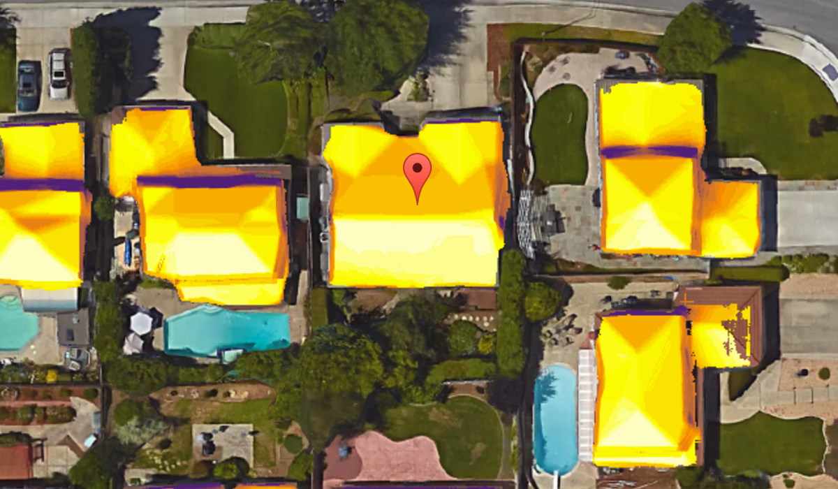
Project Sunroof 🏡 "Search for your home. Discover your solar savings potential. See what’s possible with solar in your U.S. or Puerto Rico community."
Rewiring America: Track Your Local Pace of Progress "These projections from Rewiring America worked backwards from the emissions targets for 2050, and forward from current sales of machines for cooking, water heating, space heating, transportation, and rooftop solar to set a number of new clean electric machines that must be sold each year to reduce emissions from fossil-fueled machines. Type your city, county, or state into the search bar to get those numbers broken down for your area, by each machine category.
While creating this tool, one of things we found is that some individual communities and states are leading the way: their goals are bolder than the rest of the country and so don’t match the path laid out in our data. That’s a great problem to have. So our tool should not be considered the only source of its kind -- but one that reflects only one of the possible paths to decarbonization."
USA
USA
Agrivoltaics Map 🍅 "This dynamic map represents a census of agrivoltaic installations located across the United States. The map is constantly expanding as new sites are developed. If you are aware of agrivoltaic sites that should be added to the map or have a correction..."
Clean Energy Authority: Solar Incentives and Rebates By State, County, City and Utility 💰 use the map or scroll down for a list of states.
Project Sunroof 🏡 "Search for your home. Discover your solar savings potential. See what’s possible with solar in your U.S. or Puerto Rico community."
Solar Geospatial Data Tools "Access our tools to explore solar geospatial data for the contiguous United States and several international regions and countries."
Solar Resource Maps and Data "Find and download solar resource map images and geospatial data for the United States and the Americas."
Solar Supply Curves NREL has developed an interactive map and geospatial data showing solar supply curves, which characterize the quantity and quality of solar photovoltaic (PV) resources."
Illinois
Oceana
Oceana
Australia
Australia
SunSPoT 🏡 "is a not-for-profit resource designed to help home owners understand the benefits and costs of installing solar panels."
Australia Solar Map (Solar Farms, Solar Roofs & Solar Parking Lots)
South America
South America
Portal Energético para América Latina "GEM’s Latin America Energy Portal offers a region-wide perspective on energy infrastructure in Latin America and the Caribbean, through interactive maps and thousands of wiki pages. The Portal synthesizes GEM’s research on nearly 5,000 projects throughout the region, including coal- and gas-fired power plants, oil and gas pipelines, oil and gas extraction sites, LNG terminals, solar farms, wind farms, coal terminals, coal mines and steel plants that meet a predetermined size threshold. Additional resources include country energy profiles, statistical data, reports, and links to organizations working towards a sustainable energy transition in Latin America and the Caribbean. ...
To learn about the various components of each GEM tracker, read About GEM’s Trackers. To receive notifications on this project, please sign up for our mailing list. If you have questions about this project, please contact the Project Manager, Gregor Clark."
Solar Hours Map For Caribbean, Central America, South America (Solar Insolation Map) "This map shows the annual and daily average solar hours (solar insolation) for various areas in the Caribbean, Central America, and South America."
South America Solar Energy Map (Solar Farms, Solar Roofs & Solar Parking Lots)
Find an Installer
Find an Installer
Organizations
Organizations
North America
North America
USA
USA
The Clean Energy States Alliance "is a national, nonprofit coalition of public agencies and organizations working together to advance clean energy.
CESA works with state leaders, federal agencies, industry representatives, and other stakeholders to develop clean energy programs and inclusive renewable energy markets. CESA members—mostly state agencies—include many of the most innovative, successful, and influential public funders of clean energy initiatives in the country."
Find A Recycler
Find A Recycler
Solar panels have a life expectancy of around 25-30 years. After that, as many as 90% are ending up in landfills, but some companies are now providing solutions, including their efforts to make solar panel recycling as efficient as possible.
Click the Solar Panel Recycling button to see our directory of PV recyclers.
Page updated
Google Sites
Report abuse